

The name "Mount Everest" encapsulates a multifaceted history that intertwines local traditions, colonial exploration, and the global push for cartographic precision. Recognized officially as the world’s highest peak during the Great Trigonometrical Survey of India in 1856, the mountain’s nomenclature remains a dynamic tale of cultural exchange and debate.
Local Names of Mount Everest
In Nepal, Everest is venerated as Sagarmāthā (सगरमाथा in Nepali), translating to "goddess of the sky" or "head in the great blue sky." The term combines सगर (sagar), meaning "sky," and माथा (māthā), meaning "head," encapsulating the peak's celestial majesty. This name highlights Nepal’s spiritual connection to its landscapes, emphasizing the mountain's role as a deity-like figure rather than just a geological formation.
In Tibet, Everest is revered as Qomolangma (ཇོ་མོ་གླང་མ), meaning "holy mother." This name was first documented in 1721 in the Kangxi Atlas, a remarkable cartographic project led by Emperor Kangxi during the Qing dynasty. The name was romanized as "Tchoumour Lancma" by French geographer D’Anville in 1733 and later adapted into Chinese as Zhūmùlǎngmǎ Fēng (珠穆朗玛峰) in the 20th century. It officially replaced older appellations like Shèngmǔ Fēng (圣母峰), meaning "holy mother peak," under the decree of the Chinese Ministry of Internal Affairs in 1952.
Both names—Sagarmāthā and Qomolangma—continue to hold cultural and spiritual importance for local communities, with increasing efforts in 2025 to ensure these indigenous names are recognized alongside "Mount Everest" in international discourse.
The British and the Controversial Name "Everest"
During the 19th century, British surveyors initially designated the peak as "Peak XV", a temporary label from the Great Trigonometrical Survey of India. Despite a general policy to preserve local names (as seen with Kangchenjunga and Dhaulagiri), the political isolation of Nepal and Tibet prevented British cartographers from identifying a widely accepted local term.
In 1865, Andrew Waugh, Surveyor General of India, proposed naming the peak after his predecessor, Sir George Everest, despite objections from Sir George himself. Ironically, Sir George argued the name would be difficult to pronounce in Hindi or by local populations. Today, the widely accepted English pronunciation (/ˈɛvərɪst/) diverges from Sir George’s preferred pronunciation, /ˈiːvrɪst/ (EEV-rist).
This decision reflects a broader imperial trend of imposing foreign names on culturally significant landmarks. In 2025, the legacy of this decision is revisited with calls to prioritize indigenous names in global contexts, highlighting the need for decolonizing geographic nomenclature.
Radhanath Sikdar: The Unsung Hero of Everest’s Discovery
Among the pivotal figures in Everest's history is Radhanath Sikdar, an Indian mathematician and surveyor. In 1852, while working for the Great Trigonometrical Survey, Sikdar identified Peak XV as the world’s tallest mountain. His precise calculations laid the foundation for its global recognition, yet his contributions are often overshadowed in mainstream narratives.
In 2025, there is a renewed push to honor Sikdar’s legacy, with campaigns advocating for the inclusion of his story in textbooks and museum exhibits across South Asia. His role is increasingly acknowledged as part of the broader history of non-European contributions to global exploration.
Misattributions and Cartographic Errors
During the 19th century, confusion about Everest’s identity was rampant. Early maps often mislabeled it as Gaurishankar, a sacred peak located about 48 kilometers away. Another incorrect designation, Deodungha, originated in the Darjeeling region but was discarded as surveys improved. These errors underscore the limitations of early cartography and the challenges of accurately mapping remote regions.
A Name That Transcends Borders
By 2025, Mount Everest’s many names—Sagarmāthā, Qomolangma, and Everest—symbolize its universal significance. These names represent more than geographical markers; they reflect the spiritual, cultural, and scientific efforts to describe a natural wonder that transcends human boundaries.
In an era of heightened environmental consciousness, Everest’s story is also a reminder of humanity’s responsibility to protect fragile ecosystems and respect local traditions. For many, the mountain is not just the world’s highest peak but a testament to collective aspirations, resilience, and the enduring spirit of exploration.
A Modern Perspective
In 2025, discussions around Mount Everest extend beyond its historical naming. With increasing focus on sustainable tourism, the region’s governments are emphasizing policies that protect Everest’s fragile ecosystem while honoring its cultural significance. Efforts to amplify indigenous voices, such as renaming global landmarks, are gaining traction, signaling a shift toward inclusivity and environmental stewardship.
Mount Everest’s enduring story serves as a beacon of human ambition and reverence for the natural world—a narrative as timeless and unyielding as its towering summit.
Mount Everest Location: Country, Continent, and Coordinaes
| Category | Location |
| Continent | Asia |
| Country | Nepal, China (Tibet Autonomous Region) |
| Coordinates | 27.9881° N, 86.9250° E |
| Region (Nepal Side) | Sagarmatha National Park, Solukhumbu District |
| Region (China Side) | Tibet Autonomous Region |
| Mountain Range | Himalayas (Mahalangur Himal Sub-range) |
| Position in the World | Tallest mountain on Earth (8,848.86m) |
| Local Names | Sagarmatha (Nepal), Chomolungma (Tibet/China) |
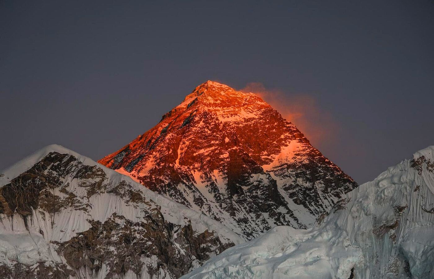
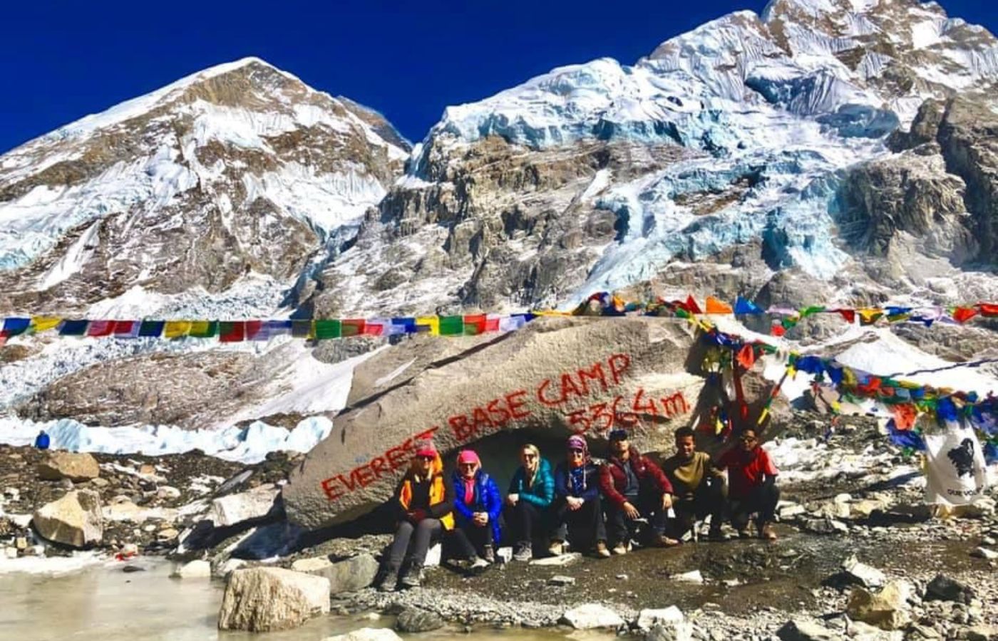
Mount Everest sits on the Nepal-China border, with the southern route in Nepal and the northern route in Tibet (China). The Everest Base Camp (EBC) is located on both sides—South EBC (Nepal) at 5,364m and North EBC (Tibet) at 5,200m.
Height of Mount Everest: Meter, Km, and feet
| Measurement Type | Height |
|---|---|
| From Sea Level (Official Height) | 8,848.86 meters (8.85 km / 29,031.7 feet) |
| From Base (Ground Level - South Side, Nepal) | 3,500 meters (3.5 km / 11,483 feet) from the Khumbu Glacier |
| From Base (Ground Level - North Side, Tibet) | 5,200 meters (5.2 km / 17,060 feet) from Rongbuk Glacier |
| Height Above Troposphere | Reaches into the lower stratosphere |
| Compared to Burj Khalifa | More than 10 times its height (828m / 2,717 ft) |
| Height Change Over Time | Rises ~4 mm per year due to tectonic activity |
Mount Everest's height was officially remeasured in 2020 by Nepal and China, confirming its 8,848.86 meters height. However, due to tectonic movements and earthquakes, Everest’s height continues to change over time.
Surveys of Mount Everest: A Chronological Account
Mount Everest’s surveying history is a fascinating chronicle of technological progress, scientific rigor, and cross-border collaboration. From the 19th-century Great Trigonometrical Survey to the latest geodetic measurements, Everest remains a symbol of humanity’s unyielding pursuit of precision.
19th Century: The Great Trigonometrical Survey and the Discovery of Peak XV
The story of Everest’s surveys began in 1802 with the Great Trigonometrical Survey of India, a British initiative to chart the subcontinent’s topography and identify the highest mountains. Surveyors, armed with 500 kg (1,100 lb) theodolites requiring 12 men to carry, faced formidable challenges—malaria, monsoons, and rugged terrain. By the 1830s, the teams reached the Himalayan foothills, but Nepal’s policy of foreign exclusion forced observations to be made from the Terai region, a hotbed of deadly diseases. These conditions claimed the lives of three survey officers and left others gravely ill.
In 1847, Andrew Scott Waugh, the British Surveyor General, turned his attention to the Himalayas, focusing on Kangchenjunga, then believed to be the world’s tallest mountain. During these observations, another peak, designated as “Peak b”, caught his attention. In 1849, surveyor James Nicolson made over 30 detailed observations from distances as close as 174 km (108 mi), confirming its exceptional height.
The breakthrough came in 1852 when Radhanath Sikdar, a mathematician working in Dehradun, calculated using trigonometric methods that Peak XV was the tallest mountain in the world. After years of verification, Waugh declared its height in 1856 as 8,840 m (29,002 ft)—a calculation so precise it deviated from modern figures by only a few meters. To give an impression of exactitude, the height was adjusted to 29,002 ft (8,839.8 m) in official reports.
Waugh humorously became known as the “first person to put two feet on Mount Everest,” a playful nod to his role despite never visiting the peak.
20th Century: Technological Advancements and Refined Measurements
The 20th century saw dramatic advancements in surveying, with new tools enabling unprecedented accuracy. Key milestones include:
- 1952–1954: The Survey of India used triangulation to measure Everest’s height as 8,847.73 m (29,028 ft).
- 1955: The International Himalayan Expedition led to the creation of a 1:50,000 photogrammetric map by Erwin Schneider.
- 1975: A Chinese survey determined Everest’s height as 8,848.13 m (29,029.30 ft), measuring from the snow cap rather than the rock base. This height became the globally accepted standard.
- 1980s: Using aerial photography, Bradford Washburn directed the creation of a highly detailed topographic map.
- 1999: An American GPS survey, led by Washburn, anchored a device into Everest’s bedrock, calculating its rock height at 8,850 m (29,035 ft) and snow height 1 m (3 ft) higher. This figure remains widely cited despite Nepal's hesitance to officially recognize it.
21st Century: Collaboration and the 2020 Height Revision
The 21st century brought renewed efforts to refine Everest’s measurements. Modern technology and international collaboration played pivotal roles:
- 2005: The Chinese Academy of Sciences measured Everest’s rock height at 8,844.43 m (29,017.16 ft) with a snow-ice depth of 3.5 m (11 ft). A political debate ensued, as China preferred the rock height, while Nepal supported the snow height of 8,848 m (29,029 ft).
- 2010: A diplomatic agreement recognized both heights, reflecting the importance of mutual acknowledgment.
- 2020: A joint survey by Nepal and China established a new official height of 8,848.86 m (29,031.7 ft). Using satellite-based GPS technology and ground-penetrating radar, this figure is considered the most precise measurement to date.
In 2025, this height continues to serve as the global standard, though scientists remain vigilant about tectonic changes and potential discrepancies.
Geological Dynamics: Everest in Motion
Everest’s height is not static. The tectonic collision between the Indian and Eurasian plates causes the mountain to rise approximately 4 mm (0.16 in) per year, while shifting northeastward by 3–27 mm (0.12–1.1 in) annually. However, localized geological phenomena, such as earthquakes, can temporarily reduce its height. For instance, the 2015 Nepal earthquake caused subtle shifts, leading to ongoing research on how these events impact Everest's elevation.
tive Perspectives: Everest Versus Other Peaks
While Everest is the highest point above sea level, other mountains challenge its supremacy based on different criteria:
- Mauna Kea, Hawaii: Measured from base to summit, it rises over 10,200 m (33,465 ft), though its height above sea level is just 4,205 m (13,796 ft).
- Denali, Alaska: Its base-to-summit height exceeds 5,600 m (18,400 ft), far surpassing Everest’s range of 3,650–4,650 m (11,980–15,260 ft).
- Chimborazo, Ecuador: Due to Earth’s equatorial bulge, Chimborazo’s summit is the farthest point from the planet’s center, despite being only 6,268 m (20,565 ft) above sea level.
The history of Mount Everest’s surveys reflects humanity’s relentless quest for accuracy and understanding. From 19th-century theodolites and manual calculations to 21st-century GPS and satellite technologies, each era of measurement has brought us closer to unraveling the mysteries of the world’s highest peak.
In 2025, Everest stands not only as a geographic marvel but also as a testament to scientific ingenuity, international collaboration, and the ever-changing nature of our planet. Whether viewed as Sagarmāthā, Qomolangma, or Everest, its story continues to inspire awe, exploration, and respect for the natural world.
Geology of Mount Everest: The Highest Rocks on Earth
Mount Everest, the highest point on the planet, is a geological masterpiece shaped by ancient marine environments and powerful tectonic forces. Comprising three major formations—the Qomolangma Formation, North Col Formation, and Rongbuk Formation—the mountain reveals a story spanning hundreds of millions of years, from the depths of ancient seas to its dramatic rise into the skies.
Geology of Mount Everest: The Highest Rocks on Earth
Qomolangma Formation
Elevation Range: Summit to ~8,600 m (28,200 ft)
The Qomolangma Formation, also called the Jolmo Lungama Formation, extends from Everest’s summit to the Yellow Band below. This layer is predominantly Ordovician limestone, interbedded with dolomite and siltstone, giving the rock a pale grey to white appearance with fine laminations.
- Fossil Evidence: Microscopic analysis of these rocks reveals remnants of ancient marine life, including trilobites, crinoids, and ostracods, confirming their origin in a shallow marine environment approximately 450–500 million years ago. Additionally, the presence of thrombolites—structures created by cyanobacteria—demonstrates biological activity that helped bind and cement these sediments.
- Structural Features: The formation is disrupted by the Qomolangma Detachment, a low-angle normal fault that separates it from the underlying North Col Formation. This fault highlights the tectonic forces that thrust these marine rocks to such extraordinary altitudes.
North Col Formation
Elevation Range: ~7,000 to 8,600 m (23,000 to 28,200 ft)
The North Col Formation makes up much of Everest’s bulk, with its upper section marked by the Yellow Band, one of the mountain’s most striking geological features.
- The Yellow Band: This distinctive layer is composed of Cambrian marble and phyllite, giving it a yellowish-brown appearance when weathered. Fossil studies have uncovered recrystallized crinoid ossicles, further evidence of Everest’s marine origins.
- Underlying Layers: Beneath the Yellow Band, the North Col Formation consists of alternating layers of schist, phyllite, and occasional marble, all highly deformed by metamorphism. These rocks likely began as deep-sea sediments, such as mudstone, shale, and graywacke, deposited over 500 million years ago during the Cambrian Period.
- Structural Boundaries: This formation is separated from the Rongbuk Formation below by the Lhotse Detachment, another low-angle fault that reflects the tectonic collision between the Indian and Eurasian plates.
Rongbuk Formation
Elevation Range: Below ~7,000 m (23,000 ft):
The Rongbuk Formation, located at Everest’s base, consists of high-grade metamorphic rocks, including schist and gneiss, some of the oldest rocks on the mountain.
- Intrusions: The Rongbuk Formation is notable for leucogranite dikes and sills, which intruded during the Late Oligocene–Miocene, about 20–24 million years ago. These granites formed through the partial melting of older sedimentary rocks, a result of intense heat and pressure during the Himalayan orogeny.
- Metamorphic Origins: These rocks were originally sediments that were buried and heated to extreme temperatures at depths exceeding 15–20 km (9.3–12.4 mi) during the Indian Plate’s collision with the Eurasian Plate.
Formation and Evolution
Mount Everest’s geology reflects its journey from ancient marine sediments deposited along the northern Indian continental shelf to its current position as the world’s highest peak.
-
Cenozoic Collision: During the Cenozoic Era (~50 million years ago), the Indian Plate collided with the Eurasian Plate, initiating the uplift of the Himalayas. These rocks were faulted, folded, and thrust southward during the process, creating Everest and its surrounding peaks.
-
Ongoing Tectonic Activity: Everest continues to rise at an estimated rate of 2–4 mm per year, driven by ongoing tectonic forces, while simultaneously shifting northeastward.
Geological Heritage and Global Recognition
In October 2022, the International Union of Geological Sciences (IUGS) designated Mount Everest’s Ordovician limestone as one of the world’s 100 geological heritage sites. This honor highlights the significance of these fossil-rich marine rocks, often called the “highest rocks on Earth,” for advancing our understanding of plate tectonics, sedimentation, and the planet’s dynamic history.
Educational and Scientific Value:
Everest’s geology serves as a reference point for studying mountain-building processes, metamorphism, and marine sedimentation, making it a key site for geological research.
Key Takeaways
Mount Everest is more than just the world’s tallest mountain—it’s a geological archive that tells the story of Earth’s transformation over hundreds of millions of years. From shallow seas teeming with ancient marine life to the monumental collision of tectonic plates, the rocks of Everest offer a glimpse into the dynamic forces that shape our planet.
In 2025, the study of Everest’s geology continues to inspire scientists and adventurers alike, highlighting its dual role as a natural wonder and a critical link to Earth’s past.
Flora and Fauna of Mount Everest
Despite its extreme environment, Mount Everest supports a fascinating yet sparse array of flora and fauna, with some of the hardiest organisms on Earth thriving at staggering altitudes.
Flora
Moss and Alpine Plants
- A resilient species of moss has been recorded at an astonishing 6,480 meters (21,260 feet), making it possibly the highest altitude plant species on Earth.
- Arenaria, an alpine cushion plant, flourishes at elevations below 5,500 meters (18,000 feet) in the Everest region, demonstrating the adaptability of life to harsh climates.
Expanding Vegetation
Recent studies using satellite data from 1993 to 2018 have revealed an expansion of vegetation in areas previously thought to be barren, suggesting ecological shifts possibly linked to climate change.
Fauna
Insects and Spiders
A black jumping spider (genus Euophrys) has been found at heights of up to 6,700 meters (22,000 feet), earning it the title of the highest confirmed non-microscopic permanent resident. Another species, Euophrys everestensis, inhabits lower altitudes around 5,030 meters (16,500 feet), feeding on windblown insects.
Birds
The bar-headed goose, famous for its ability to fly over the Himalayas, has been observed at extraordinary altitudes. In 1953, George Lowe reported seeing these geese flying over Everest’s summit.
Choughs, both yellow-billed and red-billed varieties, have been spotted as high as 7,920 meters (25,980 feet) near the South Col, showcasing incredible adaptations to thin air.
Mammals
Yaks, crucial for Everest expeditions, are known for their ability to carry loads up to 100 kg (220 pounds). Their thick fur and large lungs enable survival in the thin air and cold conditions.
Himalayan tahr, a type of wild goat, roams the region and serves as prey for snow leopards, the elusive apex predators of the Himalayas.
Other notable species include the Himalayan black bear, found at altitudes up to 4,300 meters (14,000 feet), and the red panda, which inhabits the forests in the region.
Other Species
A 2019 expedition documented a surprising range of biodiversity, including pikas and ten new ant species, highlighting the hidden ecological richness of the Everest region.
Conservation Efforts
From Nepal’s side, Mount Everest is part of the Sagarmatha National Park, a UNESCO World Heritage Site, dedicated to preserving the unique biodiversity and fragile ecosystems of the region. These conservation efforts are crucial for protecting not only the iconic mountain itself but also the remarkable life forms that have adapted to its challenging conditions.
Mount Everest’s flora and fauna may be sparse, but they represent the resilience of life under the harshest conditions. This ecological tapestry, from microscopic organisms to high-flying geese, underscores the mountain’s significance as more than just a geographical marvel—it is a living, breathing symbol of nature’s adaptability.
Climate of Mount Everest
Mount Everest has an ice cap climate (Köppen classification EF), where temperatures remain well below freezing throughout the year, even during the warmest months. The summit's extreme cold and high-altitude conditions make it one of the most inhospitable environments on Earth.
Average Monthly Temperatures (°C and °F)
| Month | January | February | March | April | May | June | July | August | September | October | November | December |
| Mean Minimum °C | −36 | −35 | −32 | −31 | −25 | −20 | −18 | −18 | −21 | -27 | -30 | -34 |
|
Mean Minimum °F |
-33 | -31 | -26 | -24 | -13 | -4 | 0 | 0 | -6 | -17 | -22 | −29 |
- January and December are the coldest months, with mean minimum temperatures plunging to −36 °C (−33 °F).
- July and August, while slightly "warmer," still average minimums of −18 °C (0 °F), showcasing the relentless cold.
Climate Change and Impacts on Mount Everest
Climate change is profoundly affecting the Everest region, including the Khumbu Glacier, which hosts the base camp for climbers on the Nepal side. The glacier is rapidly thinning and destabilizing, posing significant risks to climbers.
Planned Relocation of Base Camp
Nepal's government, advised by a dedicated committee, has proposed relocating the base camp to a lower altitude to improve safety.
Challenges of Relocation:
A lower base camp would increase the distance to Camp 1, adding difficulty to an already demanding climb.
Current estimates suggest the existing base camp will remain viable for another 3–4 years, with the move potentially happening as early as 2024.
The Everest Ice Cap in Flux
The ongoing melting of the Khumbu Glacier and other ice structures underscores the fragility of the Everest ecosystem under global warming. This melting not only affects climbers and tourism but also raises concerns about long-term water supplies for surrounding communities.
Mount Everest's climate and the growing impacts of climate change offer a stark reminder of nature's vulnerability, even in the world's most remote and seemingly untouchable places.
Meteorology of Mount Everest
Mount Everest’s towering summit extends into the upper troposphere and even penetrates the stratosphere, exposing it to extreme atmospheric and meteorological conditions. These unique factors make Everest not only a physical challenge for climbers but also an exceptional site for studying high-altitude weather phenomena.
Atmospheric Pressure on Everest
The air pressure at Everest's summit is approximately 33.7 kilopascals (4.89 psi), which is about one-third of the pressure at sea level (101.3 kPa or 14.69 psi). This dramatic reduction in pressure significantly lowers oxygen levels, making the atmosphere on the summit incredibly thin and challenging for human survival.
Weather Patterns and Wind Speeds
Everest’s altitude exposes it to the jet stream, where winds frequently exceed 160 km/h (100 mph) and sometimes reach catastrophic speeds. For instance, in February 2004, wind speeds of 280 km/h (175 mph) were recorded at the summit. These winds, combined with freezing temperatures, create extreme conditions that can endanger climbers by:
Blowing climbers into chasms.
Reducing oxygen availability by up to 14% due to the Bernoulli effect, which lowers air pressure further.
To mitigate risks, climbers aim to ascend during the spring and fall weather windows—a 7- to 10-day period between monsoon transitions when winds temporarily calm
Weather Stations on Everest
Everest hosts several weather stations that monitor high-altitude meteorological conditions, contributing vital data to climate research:
South Col Weather Station:
Established at 8,000 meters (26,000 feet) in 2008 by the SHARE project, this solar-powered station collects data on wind, temperature, and pressure.
Balcony Station:
Located at 8,430 meters (27,657 feet), this is the highest weather station on Earth.
Installed in 2019 by scientists Tom Matthews and Baker Perry, it provided groundbreaking data until it ceased transmission on January 20, 2020.
Meteorological Challenges for Climbers
Temperature Extremes: The summit experiences severe cold, with temperatures averaging well below freezing all year.
Wind Hazards: The combination of high wind speeds and reduced oxygen levels can disorient and exhaust climbers, increasing the likelihood of accidents.
Importance of Everest Weather Data
The extreme environment of Mount Everest serves as a critical natural laboratory for understanding:
High-altitude weather dynamics.
Climate change impacts on the Himalayan region, including glacial retreat and shifting wind patterns.
Mount Everest: Physical Features or Political Features
While conditions on Everest are inhospitable for permanent human habitation, the mountain remains an invaluable site for advancing meteorological and environmental science. The question seemed simple, yet it held curiosity. Is Mount Everest a political or physical feature? The map showed its towering presence between Nepal and China, right on the border. Could that make it political?
Looking closer, the answer became clear. Everest was not drawn by humans, nor shaped by laws or agreements. It had stood tall for millions of years, long before borders existed. Formed by the powerful movement of the Earth’s crust, it belonged to nature, not politics.
While countries claimed parts of it, Everest itself remained untouched by human decisions. Maps could change, borders could shift, but the mountain would always be a physical feature, created by nature’s force.
Francys Arsentiev: The Tragic Story of "Snow White" on Everest
Francys Arsentiev (January 18, 1958 – May 24, 1998) became the first American woman to summit Mount Everest without supplemental oxygen, but her achievement ended in tragedy. Known among climbers as "Snow White" due to her frozen appearance after death, her story remains one of Everest’s most haunting legends.
In May 1998, she and her husband, Sergei Arsentiev, attempted the summit multiple times before finally reaching the top on May 22. Their slow ascent, without oxygen, forced them to spend the night in the Death Zone. They became separated, and Francys was later found barely conscious, suffering from severe frostbite and oxygen deprivation. Several climbers attempted to help her, but due to the harsh conditions, she could not be saved. Sergei, who went back to rescue her, also perished. His body was discovered a year later, suggesting he fell while trying to reach her.
For nine years, Francys' body remained visible along the route, earning her the nickname "Sleeping Beauty" and "Snow White of Everest." In 2007, an expedition led by Ian Woodall moved her remains to a less exposed location, giving her a symbolic burial. Her story remains a powerful reminder of Everest’s deadly beauty.
Popular Treks in Everest Region
We, Escape Himalaya, invite you to experience the most breathtaking trekking routes in the Everest region—a journey like no other! Walk through ancient Sherpa villages, witness the majestic peaks of Everest, and immerse yourself in the beauty of the Himalayas.
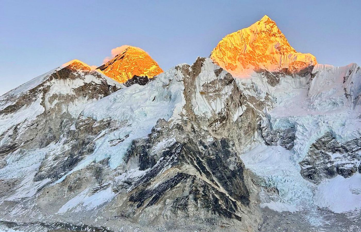
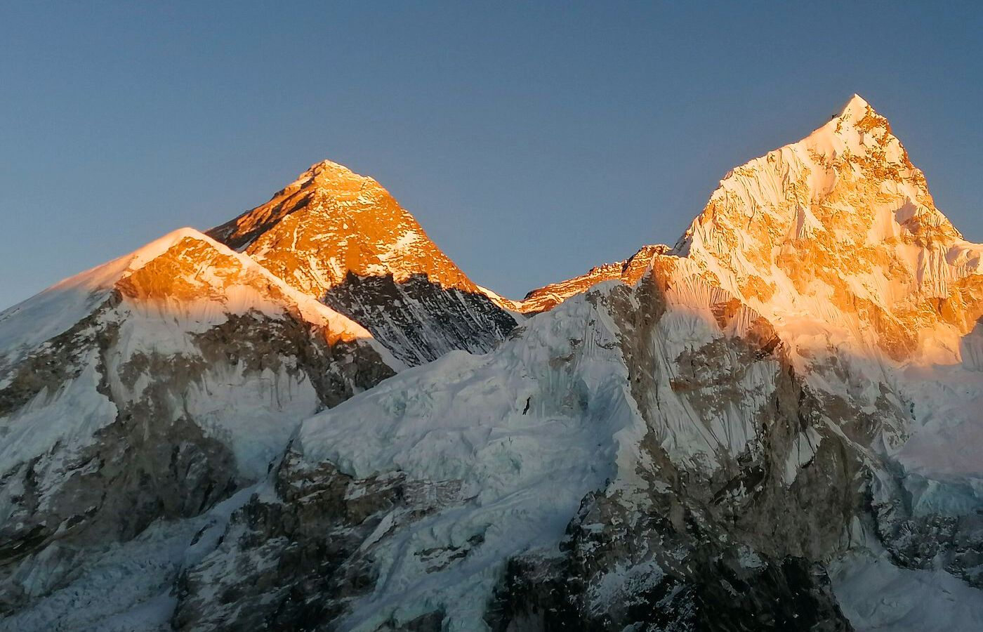
- Trek to Everest Base Camp (5,364m) – Follow the legendary trail to the foot of the world’s tallest mountain.
- Explore Gokyo Lakes (5,357m) – Discover the stunning turquoise lakes and hike to Gokyo Ri for panoramic Himalayan views.
- Short on time? Everest View Trek (3,860m) – A perfect way to witness Everest’s beauty in a shorter trek.
- Seek adventure? Everest High Passes Trek – Conquer three high-altitude passes (Kongma La, Cho La, Renjo La) for the ultimate challenge.
Join us for an unforgettable Himalayan experience! With expert guides, well-planned itineraries, and a commitment to your safety, Escape Himalaya ensures a journey of a lifetime.


